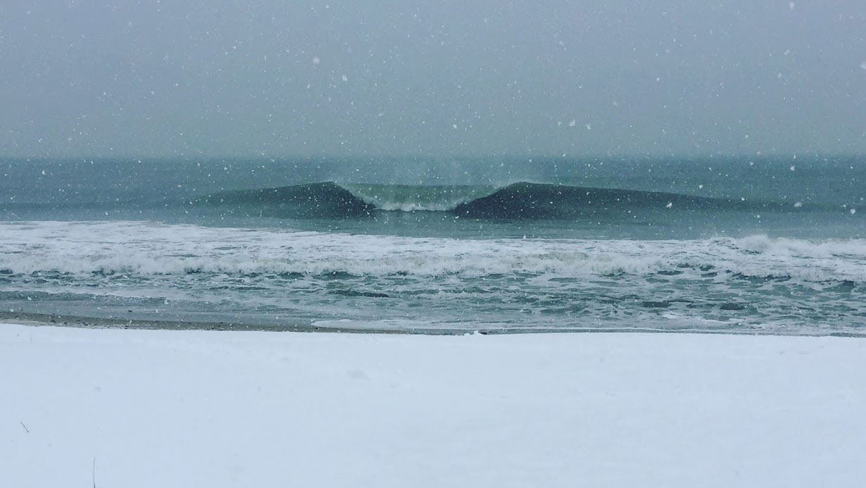
If you live in New England (or elsewhere on the east coast of the US for that matter) - than chances are you’ve experienced a Nor’easter or 2. We’re talking 50 knot winds, storm surge, freezing air temps, and whiteout conditions.
These massive extra-tropical cyclones can often bring insane weather and also destruction with them along their path. Heavy, wet snow and strong winds are the Achilles heel for power lines and tree branches. And that's nothing compared to the coastal flooding that can occur. The silver lining? Nor’easter storms can produce some pretty epic surf for the east coast...
Why are they called Nor'easters?
As you may have guessed, the reason that we call these storm Nor’easters is because of the wind direction that often occurs when the storm is at its peak in New England, often blowing out of the northeast. It’s these NE winds that bring the strongest winds and precipitation to New England.
How does a Nor'easter Develop?
The Jetstream, meandering across the United States like a giant river, is the driving force behind cyclone formation and the movement of air masses.
It all starts when the Jetstream sags into the US pushing a lovely blast of upper level Arctic air down from Canada, eh?
When this cold, upper level air gets pushed on top of the warmer, low altitude air, a Nor’easter can quickly begin to take shape. As these two air masses interact, winds begin to develop along with an upward suction of warm air into the upper level. These factors combined with the rotation of the earth lead to cyclone formation.
Sounds simple enough, right? We get our fair share of warm air thanks to the Gulf Stream, a flow of warm water from the Gulf of Mexico, around Florida, and up towards the Carolinas. But how do we lock in cold air in the upper levels long enough for a cyclone to develop?
A little thing called the NAO
The stability of the Atlantic Ocean is for sure a driver behind the formation of Nor’easter’s.The way that ocean scientists measure the Atlantics changes in stability is with something called the North Atlantic Oscillation, or NAO. We’re not going to dive too deep into this (maybe a future post?), but basically the NAO index is a comparison of the air pressure between Iceland and the Azores.
If the NAO is in a positive phase, you can expect to see strong low pressure over Iceland. This pulls storms away from the East Coast, helping to drive them across the Northern Atlantic.
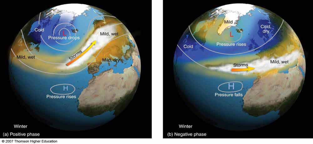
Notice the weaker low pressure during negative phase, and the lingering cold on the East Coast.
When the NAO seesaws to the negative phase is when we typically see Nor’easter’s develop. In a negative phase, the low-pressure system around Iceland is relatively weak and therefore doesn’t have enough pull, making it tough for storms to cross the northern Atlantic. Therefore storms end up lingering around the East Coast.
The negative phase also traps cold air over the US – which further fuels Nor’easter development.
All that being said, Nor’easter’s can still form during the positive NAO phase, it’s just less common.
You can monitor the current phase of the NAO here.
It's Miller time!
Once a Nor’easter develops, there are two ways to classify them using the Miller Classification: Miller Type A or Miller Type B.
Type A systems develop either in the Gulf of Mexico, or off the eastern coast of Florida/Georgia/South Carolina. These storms intensify off the East Coast as they move north towards New England. Once they get past the Carolinas and approach the Rhode Island coast, they typically spin off into the Atlantic… but not before offering up some juicy surf for a few days!
If the storm heads due north from the Carolina’s and straight up into New England, that would be the ideal situation for south swell in RI – but expect some gnarly weather and potential coastal flooding! If the storm heads north, but then curves out into the Atlantic, we will see a shifting south to east swell direction.
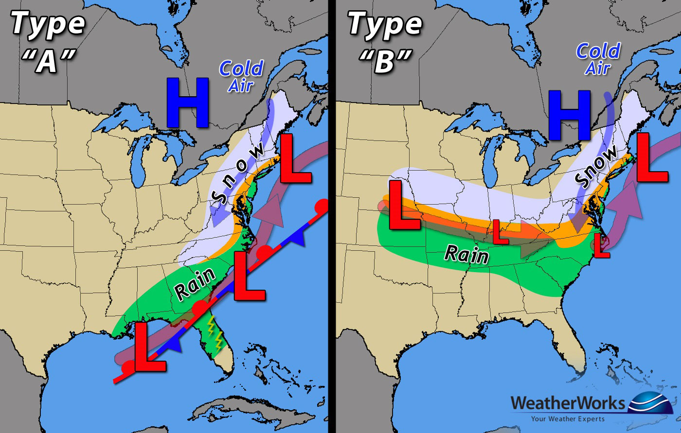
Type B systems originate in the mid-west US and slowly move towards the East Coast, remaining relatively weak. Once the storm hits the coast, it turns north towards New England and eventually out to sea. When they hit the coast, they are typically on the weak side, strengthening a bit as they turn NE over the ocean.
The surf from these systems can be as good as Type A, provided that the Nor’easter gains strength one it hits the coast and follows the Type A pattern. If it remains weak, than we should still see surf but for sure not textbook.
What the heck is bombogensis?
You may have heard this wild term thrown around during a Nor’easter event. Besides sounding like a killer band name, what does it mean?
Bombogenesis describes the rapid intensification of a mid-latitude cyclone, like a Nor’easter. To be considered a “bomb cyclone” it must drop at least 24 millibars in 24 hours – a millibar (mb) being a unit of air pressure.
This typically occurs over the ocean, where the temperature gradient (from cold upper air to warm lower level air) is greatest.
What's the difference between a hurricane and Nor'easter?
We’ve gotten this question before, so figured this is a good time to clarify.
Hurricanes are warm-core storm systems, meaning that the center is warmer than the surrounding area. Because of the temperature gradient in the atmosphere, they will lose intensity with increased height, because of the cold upper air. Hurricanes form over warm ocean water and gain energy from warm, evaporating ocean water.
On the opposite end of the spectrum, extra-tropical cyclones such as Nor’easter's are cold-core systems and therefore do not lose intensity/energy with height. Because of this upward reach, these systems can interact and be driven by the Jet stream.